Facts about Croatia: Geography, Capital and Key Information
Introduction
Facts about Croatia reveal a country of extraordinary natural beauty and historical depth, stretching from the peaks of the Dinaric Alps down to one of Europe’s most celebrated coastlines. Situated in southeastern Europe with a long shoreline along the Adriatic Sea, Croatia is home to medieval walled cities, thousands of islands, and landscapes that have drawn visitors for centuries. The country gained independence from Yugoslavia in 1991 and has since become a full member of the European Union, the Schengen Area, and the Eurozone. Whether you are a student, teacher, or geography enthusiast, Croatia rewards closer study at every turn.
Quick Facts about Croatia
- Capital city: Zagreb
- Population (approx.): Around 3,900,000 people
- Area (km²): 56,594 km²
- Currency: Euro (EUR)
- Official language: Croatian
- National Day: 30 May
Geography and Landscape
Croatia occupies 56,594 km² in southeastern Europe and has one of the most varied and dramatic coastlines on the continent. The country has a distinctive crescent shape, with its territory extending from the Pannonian Plain in the north and east, through a central highland region, and down to the Adriatic coast in the southwest. This range of environments — lowland, upland, and coastal — gives Croatia an unusually rich natural character for a country of its size.
The Dinaric Alps run parallel to the Adriatic coast and form the dominant geographical feature of the interior. These limestone mountains are heavily karst in character, meaning water has carved the rock over millennia into sinkholes, caves, and underground river systems. One of the most spectacular results of this karst landscape is the Plitvice Lakes National Park, a chain of sixteen terraced lakes connected by waterfalls and surrounded by dense forest. The park has been a UNESCO World Heritage Site since 1979 and is among the most visited natural destinations in Central and Southeastern Europe.
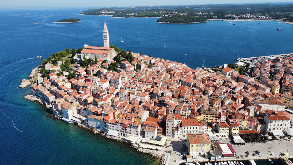
Croatia’s Adriatic coastline stretches approximately 1,777 kilometres along the mainland alone. Offshore, more than 1,200 islands, islets, and reefs dot the sea — the greatest number of islands along any stretch of the European Mediterranean. Only around 50 of these islands are permanently inhabited. The largest include Krk, Cres, Brač, and Hvar, each with its own distinctive landscape and history. The islands are a defining feature of Croatian geography, shaping the country’s culture, economy, and identity.
The highest point in Croatia is the Dinara mountain, which reaches 1,831 metres on the border with Bosnia and Herzegovina. In the lowlands to the north and east, the Sava and Drava rivers cross the Pannonian Plain before flowing into the Danube. This flat and fertile region, known as Slavonia, is the agricultural heartland of the country.
Population and Culture
Croatia has a population of approximately 3.9 million people. Zagreb, the capital and largest city, is home to around 800,000 residents and functions as the country’s political, economic, and cultural centre. Split, on the Dalmatian coast, is the second-largest city and serves as the gateway to Croatia’s island chain. Other significant cities include Rijeka on the northern Adriatic coast and Osijek in the eastern region of Slavonia.
Croatian is the official language, written in the Latin alphabet and closely related to Serbian and Bosnian. The country is predominantly Roman Catholic, and religious traditions play a visible role in festivals, community life, and architecture throughout the country. From the cathedrals of Zagreb to the Franciscan monasteries of Dubrovnik, religious heritage is woven into the built landscape.
Croatia’s culture reflects its position at the meeting point of Mediterranean and Central European influences. The Dalmatian coast carries the distinct character of centuries of trade and interaction with Italy and the wider Mediterranean world. The interior regions, by contrast, have stronger ties to the Habsburg tradition and Central European culture. This duality is visible in the architecture, cuisine, music, and local customs from one region to the next.
National Day on 30 May commemorates the first session of the freely elected Croatian parliament in 1990, which marked a decisive step toward independence. Croatia formally declared independence from Yugoslavia in June 1991, and the date 30 May — known as Dan državnosti, or Statehood Day — is observed as the principal national holiday.
3 Interesting Facts about Croatia
-
The modern necktie has its origins in Croatia. During the Thirty Years’ War in the seventeenth century, Croatian soldiers wore distinctive knotted neck scarves as part of their military uniform. French officers adopted the style, calling it “à la croate” — in the Croatian fashion — and the word “cravat” derives directly from the French rendering of “Croat.” The necktie worn in offices and formal settings worldwide traces its lineage to this Croatian military tradition.
-
Croatia has more islands than any other country bordering the Mediterranean Sea. The Adriatic coastline is scattered with over 1,200 islands, islets, and reefs. Most are uninhabited, and many are accessible only by boat, preserving a sense of remoteness that is increasingly rare in Europe. The islands range from tiny limestone outcrops to substantial landmasses with their own towns, vineyards, and centuries of recorded history.
-
Dubrovnik’s medieval walls have stood largely intact since the thirteenth century. The Old Town of Dubrovnik is entirely enclosed by fortified walls that average around 25 metres in height and reach a thickness of up to 6 metres in places. The city has been a UNESCO World Heritage Site since 1979 and has long been known as the “Pearl of the Adriatic.” Its remarkably well-preserved medieval streetscape has made it one of the most recognisable urban landscapes in Europe.
Where is Croatia Located?
Croatia is located in southeastern Europe, bordering the Adriatic Sea to the southwest. It shares land borders with Slovenia and Hungary to the north, Serbia to the east, and Bosnia and Herzegovina and Montenegro to the south and southeast. This position places Croatia at the meeting point of the Balkans, the Mediterranean world, and Central Europe.
On a map of Europe, Croatia’s distinctive crescent shape is immediately recognisable, curving from the interior of the Balkans down to the Dalmatian coast. The country joined the European Union in 2013, became part of the Schengen Area in January 2023, and adopted the euro as its currency at the same time. These memberships reflect Croatia’s close integration with the broader European community.
If you are building your understanding of European geography, placing Croatia alongside its neighbours — Slovenia, Bosnia and Herzegovina, and Montenegro — helps illustrate how the western Balkans function as a region of distinct but historically interconnected nations.
Discover More About European Countries
Croatia is one of many rewarding countries to explore across the European continent. Whether you are building a geography unit, studying independently, or looking for reliable reference material, having a consistent resource makes comparing countries across the continent much easier.
Hofma Publishing’s European Countries Books bring together key facts in a clear format designed for students, teachers, homeschoolers, and geography enthusiasts.
The European Countries Book – Extended Color Edition https://www.amazon.com/dp/B0G33G45CJ
The European Countries Book – Color Edition https://www.amazon.com/dp/B0FX9C7TS5
The European Countries Book – Black & White Edition https://www.amazon.com/dp/B0FDRXJX7C